New flood warning issued for region after night of heavy rain
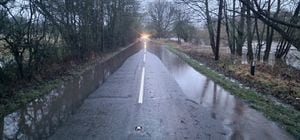
Residents living alongside the River Severn have been warned to expect flooding after a night of heavy rainfall.
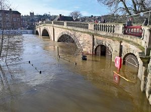
The Environment Agency has posted an updated message to inform residents in Bewdley, Bridgnorth and Stourport that river levels are expected to rise due to rainfall.
Residents in Bewdley have also been informed that due to the work to build the Flood Risk Management Scheme, the barriers at Beales Corner will not be deployed, despite the ongoing risk of the Severn bursting its banks and flooding the adjacent streets.
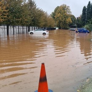
This comes after parts of Worcester were left with standing flood water from the River Severn, with images released by Worcestershire Council showing flooding on Waverley Street and Pitchcroft Car Park.
The river is expected to peak at Bewdley at between 4m to 4.3m on Wednesday morning, with the Met Office forecasting heavy rain and disruption.
The forecast read: "Heavy rain falling on saturated ground is likely to cause some travel disruption.
"Flooding of a few homes and businesses is possible.
"Spray and flooding on roads probably making journey times longer.
"Bus and train services probably affected with journey times taking longer."
A spokesman for the Environment Agency said that flooding was expected on property, roads and farmland in Bewdley and Bridgnorth and at properties at Severnside and the access road to Stourport Marina.
The spokesman said about Bewdley: "As previously communicated, the Barriers at Beales Corner will not be deployed due to the construction of the Flood Risk Management Scheme.
Predicted Peak:- 4.3m to 4.7m Wednesday morning 03/01/24.
"Flood water could be deep and fast flowing, and therefore pose a risk to life. Further rainfall is forecast over the next 48 hours.
"We expect river levels to rise until this morning 02/01/24, with further peaks expected in the coming days.
"We are closely monitoring the situation and our incident response staff are liaising with emergency services and Local Authorities.
"Please avoid using low lying footpaths near local watercourses and plan driving routes to avoid low lying roads near rivers, which may be flooded.
"This message will be updated by 5pm today, 02/01/2024, or as the situation changes."
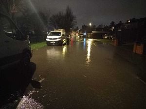
The B4194 Switchback road between Bewdley and Stourport was shown to have some flooding, but Worcestershire County Council had said the road was passable, but might close in the afternoon.
A spokesman for Worcestershire County Council said: "B4194 Switchback (Bewdley - Stourport) passable this morning & due to drop a little but very likely to be closed late afternoon today."
For Bridgnorth, the spokesman said that the predicted peak was between 4m and 4.3m, with properties on Severnside expected to be affected by flooding.
The spokesman said: "River levels are forecast to rise at the Bridgnorth river gauge as a result of heavy rainfall.
"Consequently, flooding of property, roads and farmland is expected to start between 2am and 9am tomorrow, 02/01/24.
"We expect flooding to affect properties on Severnside. Predicted Peak at Bridgnorth 4 to 4.3m Tuesday afternoon.
"Further rainfall is forecast over the next 48 hours and we expect river levels to continue to rise as a result.
"A further peak of between 4.2 and 4.7m could be possible on Friday morning based upon this forecast rainfall.
"We are closely monitoring the situation.
"Please avoid using low lying footpaths near local watercourses and plan driving routes to avoid low lying roads near rivers, which may be flooded.
"This message will be updated by 11am on 02/01/24, or as the situation changes."
For Stourport, a peak of between 4.3m and 4.7m was expected by Wednesday morning, with River Severn Sandy Lane Industrial Estate, Moor Hall Lane and Severnside Cottages expected to be hit by flooding.
The spokesman said: "River levels are rising at the Bewdley river gauge as a result of heavy rainfall.
"We expect flooding to affect properties at Severnside and the access road to Stourport Marina.
"Flood water could be deep and fast flowing, and therefore pose a risk to life. Further rainfall is forecast over the next 48 hours.
"We expect river levels to rise this morning 02/01/24, with further peaks expected in the coming days.
"We are closely monitoring the situation and our incident response staff are checking defences and clearing weed screens.
"Please avoid using low lying footpaths near local watercourses and plan driving routes to avoid low lying roads near rivers, which may be flooded.
"This message will be updated by 5pm on 02/01/2024, or as the situation changes."
The warnings of flooding come as Storm Henk is expected to bring very strong winds and heavy rain across much of southern England and Wales, with the Met Office issuing amber and yellow warnings.
Coastal areas could see gusts of 70-80mph while inland areas could see 50-60mph winds as the storm, named by the Met Office, sweeps across the country.
Forecasters said there is a good chance that power cuts could occur, with probable damage to buildings, travel disruption and a chance of injury or loss of life from flying debris.
The amber warning is in place from 10am to 8pm today, while a yellow warning for wind is in place from 8am to 9pm.
It says: "Storm Henk will bring a spell of very strong winds, causing disruption to travel and utilities.
"Heavy rain falling on saturated ground is likely to cause some travel disruption."
The weather is expected to stay unsettled throughout the week across the UK but there are signs it could calm down after the weekend, the Met Office said.
Chief Meteorologist Paul Gundersen said: "Our latest analysis of the forecast shows an increase in the likelihood of very strong wind gusts across parts of southern Wales and England, which is why we have issued this amber warning this morning and named Storm Henk.
"Storm Henk will initially bring very strong winds to the South West of England and southern Wales, with gusts of up to 80mph possible.
"As Storm Henk moves north-eastwards across the south of the UK through Tuesday, the strongest winds will also move eastwards, across the south Midlands, Home Counties and East Anglia through the afternoon and evening."