More flooding expected in the region as river banks burst and more rainfall predicted
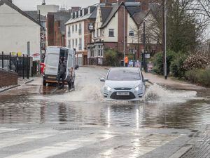
Wednesday saw another day of flooding misery for communities across the region as river levels rose and banks burst.
Watch more of our videos on Shots!
and live on Freeview channel 276
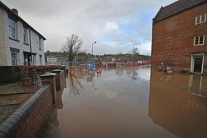
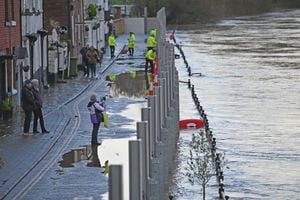
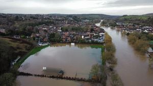
The streets next to Beales Corner in Bewdley again saw flood water creeping up along Stourport Road and onto Kidderminster Road in the Wribbenhall area of the town.
The flooding came after another heavy night of rainfall brought by Storm Henk, which brought chaos to the roads and residents across the region, and predictions of more rain over the next few days.
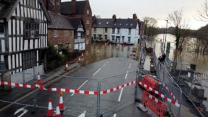
In Bewdley, the River Severn burst its banks and sent flood water spilling over onto the B4190 Stourport Road, with water running up the Kidderminster Road and along the banks of the river.
It meant the road was left closed off due to the flooding, with nearby residents forced to operate their flood defences, such as floodgates, pumps and sandbags, as no temporary defences had been set up due to the ongoing work to build flood defences on Beales Corner.
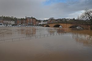
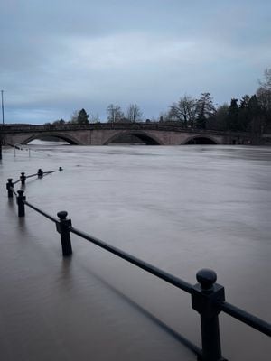
Across the river, the temporary defences were keeping the river from bursting into the town, although photos showed the river almost touching the bottom of the bridge.

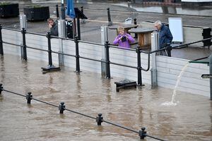
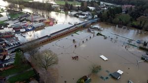
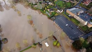
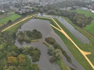
In Stourport, the parkland around the Playland Fun Park was under water, while Severnside and the access road to Stourport Marina was also hit by rising flood water.
Wyre Forest MP Mark Garnier offered his sympathies to residents affected by the flooding and said he would do whatever he could to help people.
He said: "My sympathy goes out enormously to those residents on the Wribbenhall side of the river as they are down to their property level defences and while we hope this won't be a problem when the new defences are built, it's an increasing problem right now.
"If anyone has any problems, then please reach out to me and I will see what I can do to try and help, but I know the Environment Agency are doing everything they can to mitigate the problems."
The Environment Agency said river levels around Bewdley and Stourport were high and growing steady, but warned of the potential for more rain and the possibility of a rise in river levels to more than five metres.
A spokesman for the Environment Agency said on Wednesday: "River levels remain high, but are now generally steady at the Bewdley river gauge as a result of heavy rainfall.
"Consequently, flooding of property, roads and farmland is expected to continue.
"Bewdley peaked at 4.8m yesterday evening (January 2). Additional rainfall however is forecast over the next few days which will likely lead to further river level rises in this location, and a predicted peak of 4.7m to 5.1m on Friday morning.
"We are closely monitoring the situation. Our incident response staff are liaising with emergency services and Local Authorities.
"Please plan driving routes to avoid low lying roads near rivers, which may be flooded and move possessions and valuables off the ground or to safety."
Elsewhere, in Staffordshire, the A5 between the A449 and the A41 roundabout near Weston Park closed due to flooding.
Meanwhile, Heathhouse Lane in Codsall, Cannock Road in Burntwood and Lime Lane in Norton Canes were closed to motorists and the subway at Mill Street in Cannock was also shut off.
The Environment Agency has kept a flood warning for the River Penk at Penkridge, saying that it expected river levels to remain high until Thursday afternoon.
A spokesman said: "River levels remain high, but are beginning to fall at the Penkridge river gauge, consequently, the risk of flooding remains.
"Flooding is affecting properties around Tedesley Road, and Pinfold Lane
"Further rain showers are forecast over the next 12 hours. We expect river levels to remain high until Thursday afternoon 04/01/2024.
"Our incident response staff are actively checking river levels and the weather forecast and checking defences."
The wet conditions also meant that all playing fields for football matches in Sandwell were closed off at the weekend due to the boggy conditions.
Sandwell Council made the decision after another day of heavy rainfall from Storm Henk, which had left the pitches boggy and waterlogged.
A Sandwell Council spokesman said: "We have made the decision to cancel all football matches on our parks and playing field pitches on Saturday and Sunday due to wet weather conditions caused by Storm Henk and already boggy pitches.
"The weather has made it difficult to get onto the pitches to carry out marking and any remedial work."
Rail services were getting back to normal after a difficult day on Tuesday, which saw flooding cause problems on the Snow Hill and Cross City Lines, as well as delays between Wolverhampton and Shrewsbury.
There were delays at the start of the day, with some services offering rail replacement services, but the rail network across the region was back to full service by the end of the day.
The Met Office has said that the weather is looking to be drier across the region, although warned of more rain and said a yellow National Severe Weather Warning for rain had been issued to run until the early hours of Friday.
Met Office chief meteorologist Matthew Lehnert said: “The track of the heaviest rain remains uncertain but there is chance of 20 to 30 mm of rain falling in a 6 to 9 hour period for a portion of the warning area, with a few places seeing as much as 40-50 mm.
“Much of this rain is falling on already wet ground and therefore, impacts are more likely.
"Meanwhile, a stalled weather front will continue to bring rain and showers across the northeast.”
The Met Office did also say that the rain would then begin to ease and was set to be replaced by colder weather over the next week.
A spokesman for the Met Office said: "The rain or showers will then ease with many regions becoming fine and dry over the weekend as high pressure looks likely to become established either over the UK or just to the north of the country.
"This will mark a change in weather with a move to a colder, drier and settled period for most.
"It will become rather cold next week with lower-than-average temperatures across much of the country.
"Frost is likely overnight and, given the ground moisture, calm conditions, and long nights, there is also a risk of fog."