River Severn receding but fairground and sports clubs remain under water
The water level is receding but flood warnings remain in place along the River Severn as towns continue to deal with the aftermath of Storm Dennis.
There were four severe flood warnings in place for the Severn on Thursday afternoon, with three of these in Worcestershire and one in Ironbridge, all warning of a danger to life.
Meanwhile less severe flood warnings were in place for Bridgnorth, Bewdley and Stourport-on-Severn, where many riverside areas remain under water, as well as for Shrewsbury where most of the flood water has cleared but the river remains very high.
With England having already received 144 per cent of its average February rainfall, the Severn peaked at 6.52m in Ironbridge and 5.03m in Bridgnorth on Tuesday evening before reaching 5.24m in Bewdley on Wednesday morning.
By 3pm on Thursday it was down to 4.5m in Bewdley but the flood barriers remained up with 4.25m the level where property flooding is deemed possible.
Despite the flooding, the Severn Valley Railway has continued running between Bridgnorth and Bewdley for the busy half-term period, with the elevation of the railway keeping the line clear of water while providing dramatic views of the flooding.
WATCH: Flooding viewed from Severn Valley Railway
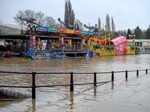
However in Stourport-on-Severn the Treasure Island fairground is badly flooded and on the opposite side of the river footballers have been left without anywhere to play or train.
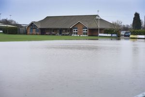
The Stourport Swifts ground in Stourport-on-Severn fell victim to the floods, with its pitch, clubhouse and training ground all flooded.
Members of the Midland Premier League club have been in to start the clear up, but it could be weeks until it's back to normal.
Press officer for Stourport Swifts Ian Johnson said it felt like the club had "dodged a bullet".
He said: "If it had been six inches higher then we would have been in a right mess.
"It all happened on Tuesday night, when the river exploded. The whole pitch and training ground was underwater. Luckily its receded now.
"It also hit the clubhouse, which is on two levels, so the cellar and toilets were flooded but fortunately the bar and changing rooms were untouched.
"We've been in mopping up the last few days, we can get into the clubhouse now but the floors are black with mud. We recently painted the floor as well, which we'll have to do again."
The Stourport Swifts teams are now training at nearby all-weather pitch at King Charles School in Kidderminster but Ian said it would be at least six weeks before they could get back to their usual home at Walshes Meadow.
Bosses have since set up an online fundraiser to try and raise money to help get the club back up and running which can be donated to at justgiving.com/crowdfunding/stouportswiftsfc.
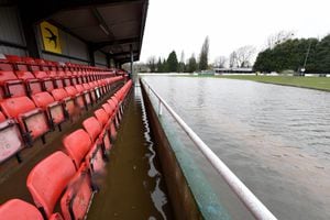
The Swifts are one of many sports clubs based near rivers to have been affected by flooding this week, with Bridgnorth Rugby Club also fully flooded further up the Severn.
At Stafford Cricket and Hockey Club, another major clean-up is under way after the club flooded for the second time in four months.
The club, based between a brook and the River Sow, had been due to open for the first time since October's flooding this month but the reopening night has now had to be postponed.
Across the country
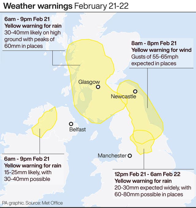
Yellow weather warnings for rain and wind remain in place throughout the week in the north of the UK.
A total of 91 flood warnings remained in place across England and Wales on Thursday afternoon, alongside the six threat-to-life severe flood warnings.
The more extreme warnings were all near the English Welsh border, around the rivers Severn, Wye, and Lugg, where people have already experienced flooding.
There are also 154 flood alerts.
Met Office forecaster Grahame Madge said: “There is still heavy rain in the forecast, and some of this will be falling on areas already affected by flooding.”
Overnight, a new weather front will bring rain to parts of Northern Ireland and Scotland, and will move south towards the Lake District and the North Pennines by morning.
Mr Madge explained: “The yellow warning is in place from Sheffield to North Yorkshire and beyond.
“We are expecting 20-30mm of rain widely across that area, with as much as 60-80mm in some places.”
Capel Curig in Snowdonia, north Wales, has had the highest rainfall of the last day, with 80mm falling in the 24 hours to 10am.
Levens Hall, in Cumbria, was subjected to 55.2mm of rain, and Morecambe, Lancashire, got 51.6mm over the same period.
Meanwhile a multi-agency briefing held on Thursday heard emergency planners may have to re-think “models for what unprecedented looks like” following the widespread flooding.
The meeting at West Mercia Police HQ at Hindlip Hall, near Worcester, included representatives from local councils and other agencies tasked with flood prevention and recovery.
Asked to comment on forecasts for levels on the Wye and Severn on Friday, Environment Agency deputy director Dafydd Evans said: “Our current models are predicting that those levels will be significantly less than what we have seen from Storm Dennis.”
But Mr Evans urged people living near rivers to remain vigilant, adding: “We continue to see some rain over the weekend – the likely result of that is that it is going to keep flows and river levels very, very high.
“That’s why we are still asking people to be vigilant – there will be water on roads and water around properties.
“Unfortunately the forecast into next week from the Met Office is that it still remains unsettled, so we will have to see into next week how that goes.
“But we are ready for that.
“We are constantly looking ahead three to five days to ensure we get that balance right between what we put into response and what we put into recovery.”
Explaining what had contributed to record flooding levels, Mr Evans continued: “Part of what we saw with Storm Dennis that was such an issue is that heavy rain was really quite widespread over the whole of West Mercia – and when you get that heavy rainfall not just in the headwaters but all through the catchments that’s what really led to those very, very high record levels.”