31 photos show flooding in Stourport and Bewdley as flood barriers are made higher
Drone photos give an aerial view of the flooding affecting Stourport and Bewdley as the latter's flood barriers were increased in height.
Watch more of our videos on Shots!
and live on Freeview channel 276
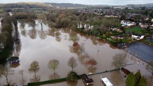
Our photographer, Tim Sturgess, flew a drone over Stouport and Bewdley on Wednesday morning, showing the extent of the flooding around the towns.
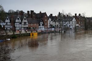
Areas of land around the river in Bewdley and Stourport have seen flooding as the heavy rainfall of the last week and overnight caused river levels to rise and banks to burst.
In Bewdley on Wednesday, Environment Agency staff were adding slats to raise the levels of the Severnside demountable barrier as water levels continued to rise.
The streets next to Beales Corner have again seen floodwater creeping up along Stourport Road and onto Kidderminster Road in the Wribbenhall area of the town.
The River Severn had burst its banks and sent floodwater spilling over onto the B4190 Stourport Road, with water running up the Kidderminster Road and along the banks of the river.
Meanwhile, in Stourport, the Playland Fun Park and the parkland around it are under water, while Severnside and the access road to Stourport Marina have been hit by rising flood water.
Wyre Forest MP Mark Garnier has offered his sympathies to residents affected by the flooding and said he would do whatever he could to help people.
He said: "My sympathy goes out enormously to those residents on the Wribbenhall side of the river as they are down to their property level defences and while we hope this won't be a problem when the new defences are built, it's an increasing problem right now.
"If anyone has any problems, then please reach out to me and I will see what I can do to try and help, but I know the Environment Agency are doing everything they can to mitigate the problems."
Stourport:


Bewdley: