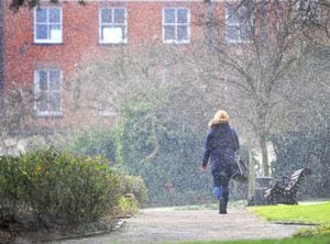
Snow flurries arrive as cold snap bites in the West Midlands
Snow has fallen across the West Midlands this afternoon as forecasters warned there is more to come.
A band of wintry weather has brought hill snow and a risk of ice to large parts of the country today.
Yellow warnings of ice remain in place today as cold air moves in behind the rain yesterday.
Temperatures of 2C (36F) were recorded in Wolverhampton this afternoon with flakes of snow lying in certain spots.
Heavier snow showers are due to fall at around 8pm tonight with temperatures falling to -1C (30F) in the early hours tomorrow.
Snow fall was also captured in Great Barr this afternoon.
WATCH: Latest weather forecast
Met Office meteorologist Sophie Yeomans said: "Most of the country is in the colder and showery air.
"The snow is mainly on the hills, while for most places the showers are falling as rain and maybe a bit of sleet.
"We've got some ice warnings; the weather front that has gone through has left rain on the ground, so as the air temperatures start to drop ground temperatures will be below zero and that's giving the risk of ice across most of the UK.
"So look out for any areas where the surfaces haven't been treated. On untreated surfaces there's a risk of slips and falls.
"There's also a risk of some icy surfaces on any untreated roads."
How long will it stay cold and how cold will it get?
Watch The Met Office makes of the cold snap here: